Using Earth Observation Satellite technology, Big Data, Artificial Intelligence, Machine Learning, Data Analytics, and Geographic Information system (GIS) to inspect disasters in each area such as village, sub-district, district and provincial levels together with Conventional surveys (Officers visit the area to inspect the damage), This will help to detect the disaster accurately, quickly, covering the actual damaged area and also use less budget. In addition, display of disaster-prone areas such as repeated floods or repeated droughts, this will help people to plan or deal with disasters effectively.
![]()


It was found that there were 221,884 rai of flooded areas
| District | Flood (Rai) |
| Chum Saeng | 118,460.07 |
| Tha Tako | 48,467.50 |
| Mueang Nakhon Sawan | 21,098.38 |
| Krok Phra | 13,581.96 |
| Phayuha Khiri | 10,147.80 |
| Kao Liao | 6,374.33 |
| Banphot Phisai | 1,748.39 |
| Lat Yao | 734.52 |
| Nong Bua | 571.94 |
| Mae Poen | 491.40 |
| Phaisali | 107.44 |
| Chum Ta Bong | 53.66 |
| Mae Wong | 46.69 |
| Total | 221,884.07 |
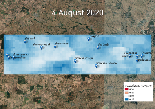
Inspect the drought affected areas by using satellite data together with Artificial Intelligence (AI) and Machine Learning (ML)
Examples of drought-affected areas Nong Bua Sa-at Subdistrict, Bua Yai District, Nakhon Ratchasima Province
Drought analytics comparing 2019 and 2020

* Department of Disaster Prevention and Mitigation announced the condition of "drought" on August 5, 2019.
